
Nearly 50 wildfires are burning this morning from Minnesota to California.
July 6, 2020, 1:41 PM
4 min read
Share to FacebookShare to TwitterEmail this articleNearly 50 wildfires are burning in the U.S. this morning from Minnesota to California.
Some of the worst fires this morning are the Soledad Fire north of Los Angeles which is currently 1,100 acres in size and zero percent contained and has caused the evacuation for an estimated 200 to 300 people.
The Crews Fire south of the San Francisco Bay area has burned 1,000 acres of land and is also zero percent contained.
Gusty winds of up to 40 mph are moving into the Western U.S. from northern California all the way to Wyoming.
Seven states from California to Wyoming are under Red Flag Warnings for these gusty winds with very dry conditions already in place.
Seven states from California to Wyoming are under Red Flag Warnings for these gusty winds with very dry conditions already in place.
Seven states from California to Wyoming are under Red Flag Warnings for these gusty winds with very dry conditions already in place.ABC NewsMeanwhile in the East, strong storms have moved through the country over the holiday weekend from Minnesota down to New Orleans, east to the Carolinas and into the Mid-Atlantic.
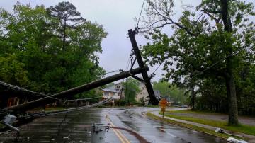
Near Charlotte, North Carolina, a tree fell on a home killing a person inside and in Maryland winds knocked down a tree which fell on a home with 20 people inside causing many injuries.
In the Twin Cities, heavy rain caused flash flooding stalling cars on the streets.
Meanwhile, in New Orleans, storms brought nearly 7 inches of rain over the weekend and produced flash flooding.
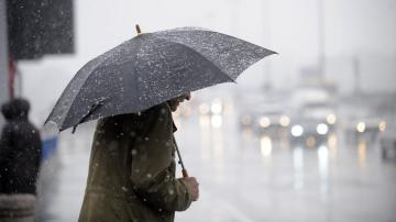
Today, severe storms are expected from Montana all the way to Wisconsin with damaging winds and hail being the biggest threat with a few torandos possible as well.
A frontal system is expected to slowly move through the Northeast this afternoon bringing a chance for strong to severe storms with gusty winds and heavy rain.
A stalled frontal system and a tropical wave along the Gulf Coast could bring heavy rain and a threat for flash flooding for the Gulf Coast states over the next few days with, locally, more than 4 inches of rain possible from Texas all the way to the Carolinas.
A stalled frontal system and a tropical wave along the Gulf Coast could bring heavy rain and a threat for flash flooding for the Gulf Coast states over the next few days with, locally, more than 4 inches of rain possible from Texas all the way to the Carolinas.
A stalled frontal system and a tropical wave along the Gulf Coast could bring heavy rain and a threat for flash flooding for the Gulf Coast states over the next few days with, locally, more than 4 inches of rain possible from Texas all the way to the Carolinas.ABC NewsElsewhere, a Heat Advisory has been issued from Rochester, New York, to Philadelphia where the heat index could reach 90 to 100 degrees.
Also, Chicago is set to continue its streak of 90 degree weather making it the hottest summer in the city so far since 2012.
A Heat Advisory has been issued from Rochester, New York, to Philadelphia where the heat index could reach 90 to 100 degrees.
A Heat Advisory has been issued from Rochester, New York, to Philadelphia where the heat index could reach 90 to 100 degrees.ABC News