A heatwave is also expected in the Southwest.
May 23, 2020, 10:50 AM
4 min read
4 min read
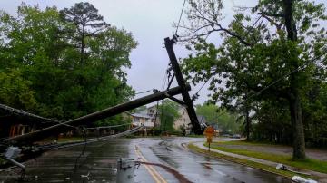
Share to FacebookShare to TwitterEmail this articleSevere storms moved across the southern Plains to the Southeast on Friday, leaving a variety of storm damage in their wake, including two deaths in the Carolinas. The storms produced four tornadoes and two wind-related fatalities due to downed trees and power poles in North Carolina and South Carolina.
The threat for severe weather continues over Memorial Day weekend as thunderstorms are making their way across Oklahoma, Arkansas and Texas Saturday morning.
This first round of storms is expected to fizzle out by the early afternoon as a low-pressure system continues to move to the east.
The threat for severe weather continues over Memorial Day weekend as thunderstorms are making their way across Oklahoma, Arkansas and Texas Saturday morning.
The threat for severe weather continues over Memorial Day weekend as thunderstorms are making their way across Oklahoma, Arkansas and Texas Saturday morning.ABC NewsStorms begin to fire across Illinois, Texas, Oklahoma, Nebraska and the Dakotas by Saturday evening. Some storms could be severe.
The main threats in the severe risk areas include damaging winds and hail. There is, however, a tornado risk in the Midwest Saturday night.
The main threats in the severe risk areas include damaging winds and hail. There is, however, a tornado risk in the Midwest Saturday night.
The main threats in the severe risk areas include damaging winds and hail. There is, however, a tornado risk in the Midwest Saturday night.ABC NewsMore storms are in the forecast for the Northeast Saturday, but the region should clear up in time for Memorial Day.
Showers will taper off throughout the afternoon hours Saturday for the mid-Atlantic states as the system moves into the Northeast. The damp weather exits the Northeast Saturday evening.
Showers will taper off throughout the afternoon hours Saturday for the mid-Atlantic states as the system moves into the Northeast. The damp weather exits the Northeast Saturday evening.
Showers will taper off throughout the afternoon hours Saturday for the mid-Atlantic states as the system moves into the Northeast. The damp weather exits the Northeast Saturday evening.ABC NewsIt will be in the 60s and 70s from Boston to Philadelphia Saturday. Temperatures will be in the 80s south of Washington, D.C.
Memorial Day is looking dry on both coasts, with the exception of Florida. The middle of the country is looking at shower & thunderstorm chances for Monday.
Memorial Day is looking dry on both coasts, with the exception of Florida. The middle of the country is looking at shower & thunderstorm chances for Monday.
Memorial Day is looking dry on both coasts, with the exception of Florida. The middle of the country is looking at shower & thunderstorm chances for Monday.ABC NewsThere is also a red flag warning in effect from Saturday afternoon to Saturday night as relative humidity will be very low. Winds are expected to gust to 35 mph at times. This could perpetuate any new or existing fires.
Along the West Coast, excessive heat alerts for central and northern California are effective Tuesday through Thursday. Alerts in southern California into Nevada and Arizona are effective Wednesday through Friday.
Temperatures will be in the triple digits to kick off the week in many places with heat index values even higher. The risk for heat-related illness is high, especially with outdoor activities encouraged amid social-distancing regulations.


