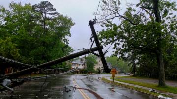
Another round of storms is expected to follow a cold front across Minnesota.
August 9, 2020, 12:08 PM
4 min read
Share to FacebookShare to TwitterEmail this articleA line of thunderstorms is moving across portions of Missouri and Illinois this morning.
Flash Flood Watches are in effect as some spots could see as much as 2 to 4 inches of rain with due to thunderstorms.
Another round of storms is expected to follow a cold front across Minnesota, South Dakota and Nebraska as it moves through the region this afternoon and evening.
Storms are expected to continue through the overnight hours as they spread into parts of Wisconsin by sunrise on Monday.
Another round of storms is expected to follow a cold front across Minnesota, South Dakota and Nebraska as it moves through the region this afternoon and evening.
Another round of storms is expected to follow a cold front across Minnesota, South Dakota and Nebraska as it moves through the region this afternoon and evening.
ABC NewsSome storms could be strong to severe, with large hail and damaging winds in excess of 60 mph being the main threats. The tornado threat remains low at this time.
A heat advisory is in place across portions of southeastern Nebraska, southwestern Iowa, eastern Oklahoma and northwest Arkansas as heat index values are forecast to be in the 100s across much of the Southern Plains to the Mississippi Valley.
A heat advisory is in place across portions of southeastern Nebraska, southwestern Iowa, eastern Oklahoma and northwest Arkansas as heat index values are forecast to be in the 100s across much of the Southern Plains to the Mississippi Valley.
A heat advisory is in place across portions of southeastern Nebraska, southwestern Iowa, eastern Oklahoma and northwest Arkansas as heat index values are forecast to be in the 100s across much of the Southern Plains to the Mississippi Valley.
ABC NewsAfter a brief trend of below average temperatures in the mid-Atlantic and the Northeast, temperatures are forecast to return to the 90s plus for major metros like Boston, New York, Philadelphia and Washington, D.C.
Elsewhere, a tropical wave is located a few hundred miles south-southwest of the Cabo Verde Islands and has a 20% chance of development in the next 48 hours.
Slow development is possible over the next few days while the cluster of showers and thunderstorms moves westward across the tropical eastern Atlantic.
An “extremely active” Atlantic hurricane season is expected this year as a number of factors were taken into consideration.
An “extremely active” Atlantic hurricane season is expected this year as a number of factors were taken into consideration.
An “extremely active” Atlantic hurricane season is expected this year as a number of factors were taken into consideration.
ABC NewsFirst, there is a very active west African monsoon meaning that the waves, or disturbances, that move west off the coast of Africa expected to be more capable of becoming better organized as they move into the Atlantic Ocean.
Second, tropical cyclones thrive in environments where the wind is calmer and does not change as much with height. This is called vertical wind shear.
In the month of July, the average wind shear in the Atlantic was observed as the second lowest on record since 2005 meaning potentially a more favorable environment for tropical systems to thrive if the trend continues.
Very warm water temperatures help sustain tropical cyclones and the warmer the water, the more fuel it has to thrive on.
The odds of an El Nino to develop -- cooler Atlantic water temperatures -- this summer into the fall are extremely low.


