
Isaias made landfall as a Category 1 Hurricane late Monday night
August 4, 2020, 11:44 AM
4 min read
Share to FacebookShare to TwitterEmail this articleTropical Storm Isaias is racing up the east coast this morning with the center of the storm nearing southeast Virginia.
The storm is moving at 28 mph towards the north-northeast with sustained winds at 70 mph with locally higher wind gusts.
Strong winds, flash flooding and tornadoes will spread northward along the entire mid-Atlantic and Northeast in the next few hours.
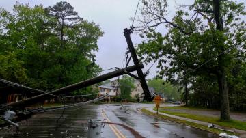
Isaias made landfall as a Category 1 Hurricane late Monday night in Ocean Isle Beach, North Carolina, with sustained winds of 85 mph.
Wrightsville Beach, North Carolina, had a gust of 84 mph overnight.
Isaias was the fifth named storm to make landfall in the U.S. this year and this is the earliest on record for the fifth named storm to make landfall in the continental U.S.
There have already been five reported tornadoes and numerous tornado warnings as Isaias came ashore.
There is currently a tornado watch from North Carolina to New Jersey this morning and the tornado watches will likely be expanded well into the Northeast as the tornado threat spreads northward.
By mid-morning the center of the storm will be racing through the Delmarva peninsula with possible tornadoes and damaging winds in Delaware and southern New Jersey.
By mid-morning the center of the storm will be racing through the Delmarva peninsula with possible tornadoes and damaging winds in Delaware and southern New Jersey.
ABC NewsThe forecast track has the storm racing up the east coast today and it should happen quickly and dramatically.
By mid-morning the center of the storm will be racing through the Delmarva peninsula with possible tornadoes and damaging winds in Delaware and southern New Jersey.
Meanwhile, a bullseye for flash flooding will develop from Northern Virginia to Pennsylvania.
By noon, the center of the storm is expected to pass through Philadelphia with powerful winds rocking the Jersey shore, as well as tornadoes likely coming onto land in New Jersey and torrential rain is expected to hit Pennsylvania.
By noon, the center of the storm is expected to pass through Philadelphia with powerful winds rocking the Jersey shore, as well as tornadoes likely coming onto land in New Jersey and torrential rain is expected to hit Pennsylvania.
ABC NewsBy noon, the center of the storm is expected to pass through Philadelphia with powerful winds rocking the Jersey shore, as well as tornadoes likely coming onto land in New Jersey and torrential rain is expected to hit Pennsylvania.
By 4 p.m., the center of Isaias will be passing west of New York City and torrential rain should fall in New York state.
Elsewhere, powerful winds will overtake Long Island, Connecticut, as well as possible tornadoes moving through southern New England.
By 8 p.m., Isaias will be making a run for Canada and the tornado threat will be lifting into northern New England.
As the storm makes its closest approach to New York City and Philadelphia, wind gusts will likely exceed 70 mph, especially on the Jersey Shore.
Where the torrential rain does fall, however, rainfall accumulations likely will reach four to six inches and will likely result in flash flooding and river flooding before tomorrow when Isaias will be gone.
Where the torrential rain does fall, however, rainfall accumulations likely will reach four to six inches and will likely result in flash flooding and river flooding before tomorrow when Isaias will be gone.
ABC NewsThis is expected to result in damage and power outages with waves offshore of New Jersey that could break as high as 10 feet.
Where the torrential rain does fall, however, rainfall accumulations likely will reach four to six inches and will likely result in flash flooding and river flooding before tomorrow when Isaias will be gone.